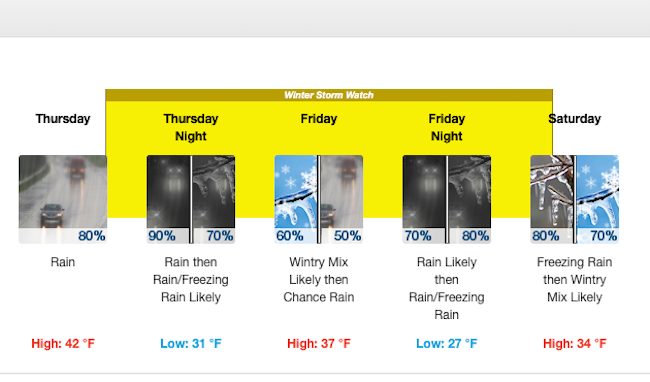


The latest National Weather Service forecast for Salem on Wednesday, Feb. 10.
Salem, it’s likely to be messy out there the next few days with rain, freezing rain and snow all possible, according to the National Weather Service.
A winter storm watch is in place from Thursday afternoon through Saturday.
Forecasters say Salem is likely to be on the line Thursday night, with snow forecast to the north and rain to the south.
In the city?
If cold air filters farther south, be ready for snow.
LINK: The latest forecast
The latest forecast for Salem calls for rain starting late Thursday night and then freezing rain after around 4 a.m. Friday. Snow is “likely” between 7 a.m. and 10 a.m, and then shifting back to rain with “little or no snow accumulation expected,” according to the forecast.
“Another juicy system pushes in Saturday,” the forecast said, with the possibility of “substantial freezing rain in the central valley and parts of the Coast Range.”
The Willamette Valley to the north of Salem could see 3 to 5 inches of snow on Saturday.
And the Cascades could get up to a foot of snow Thursday night and an additional 10 to 15 inches Friday night. The Columbia Gorge also is expected to get several inches of snow.
The city of Salem wasn’t waiting for more certainty in the forecast. The city announced that crews already had applied deicer in hilly terrain in south and west Salem and on bridges.


